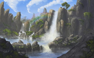
The Underground River Thäl, running through the plains
Celadon is the general name for a large grassland in the very north of Atheryin, east of the Eýn Mountains and west of the Pearlknife Mountains. To the south is the Ohkorra Desert. The region holds some of the greatest diversity of cultures and political bodies seen on the planet, and is renowned for its captivating beauty. Formerly the area was a large mountain range, until the region was effectively flattened by a war between two spirits, believed to be Earth-gods.
Etymology[]
The name is derived from the fields' deep green color, that seems to extend endlessly for miles. It was given by its human inhabitants, but was not its official name for a very long time. Traditional names from human settlements such as Helmbridge and Ravenwood were proto-Atherin words similar to its current name, ranging anywhere from the archaic "Seiladun" to a less developed Lyrian-influenced "Felkýn".
Originally the Lyrians called Celadon "Velkain", meaning simply "West Plains". Among commoners of the empire it was referred to just as "Vel" or "ta-Vel", calling it just the West, as it was an area considered to be Lyria's new frontier. Elven settlements, specificallly Derethäl, were influenced by Lyrian naming schemes as well, and over the years generated many bastardized Lyrian terms to mock the eastern side of the region. Names like these fell anywhere between "Sturon" (meaning quite literally, "Slave Land") and overly complex slurs like "Nässulurinũr" (translating directly to "Cow Shit Hell", referring to the large amount of cow pastures in the eastern fields).
Geography[]
The Ohkorra Desert and Celadon share only one similarity: they were both shaped artificially, after the creation of Atheryin. However, two separate events changed these locations, and Celadon attributes this to the Fall of Eolas, a world-changing event that destroyed much of its former area, referred to as Nortadder by historians. It was formerly a land of dense, forested foothills to the former Ohkorralta. The area reportedly contained large cave systems, which have since been uncovered after the area's flattening. This made for breathtaking scenery, and a curious, partially-underground river system.
Eastern Regions[]
Closer to Ebon Glade Forest, the area starts with a more hilly and fertile ecosystem, and the further south one goes, the warmer and significantly greener it gets. This small stretch of Celadon, near Whorn-ik and the boundaries of the Fissure is known very well for its beautiful valleys, rolling hills, and large basalt cliffs, forming the eastern border to the Ohkorra Desert. The area has always been full of farms and mines alike, and holds one of the largest agriculture and obsidian trades in the world. Its extremely volcanic soil can grow even the neediest of plants, and because of this, the valley has been used for centuries as a farm for plants taken from the Kira Jungle and other exotic regions.
More northward, toward Eboncross, the region becomes temperate, and significantly cooler. Around these areas (and most of the northern, coastal Celadon), the climate is far more like the Nokanian Aihun, possessing a humid continental climate. This climate makes for warm, humid summers, but harsh, snowy winters. Curiously, however, despite being a climate prone to large, dense forests, Celadon has never regrown its ancient forested lands, save the few patches that were never flattened in the first place. Some believe this is a curse, and others, a gift, but scholars have yet to determine what the exact cause is. Even further north, as mentioned before, the ancient forests are minutely retained around Ravenwood. The area hosts a very unique ecosystem as a result, and is a very prominent area for studies by scholars and wandering nature-lovers alike.

One of the river's many drop-off points.
Slightly west, hugging the unofficial divide between Elven Celadon and Human Celadon, is the heart of Celadon itself: an area of rolling, green pastures, with no end in sight. Closer to the River Thäl, however, are the more dramatic geographic scenes the area is so well known for. Here, large parts of the river drop into huge, ditch-like pools, and eventually go underground completely, until reaching Lake Tälun in the far west. The underground expanses and sheer drops can be attributed to the old mountain cave systems, now exposed by the flattening of what was once a large forested highland. Away from the river, however, there are still many more exposed cave systems, hosting unique micro-climates and other odd vistas. It is truly an area for the most adventurous of explorers, and its many old dungeons and inexplicably ancient dwellings are even more of an incentive for the casual dungeon-crawler.
Western Regions[]
Although the middle reaches of Celadon's western side are relatively identical to its counterpart across the cultural divide, but it is there that the similarities end. The further west one goes, the more natural water can be found... the River Thäl's natural caverns begin to become labyrinthine and spread all over the area, creating ponds, lakes, and brooks when the cavernous areas drop into lower areas. With such an abundance of water, the area has since regrown many of the old forests (it being at the foot of the massive Eýn Mountains helps, as well).
However, it would be unwise to assume that the forested lands make for poor farms. In fact, the farmlands here grow plentiful crops without deforesting, as the foothills of the nearby Eýn Mountains are relatively flat, the plentiful water makes farming even easier than it is in the east. However, the climate in these foothills (or
